Over the past few years, dam safety has been the subject of international media coverage due to significant incidents at dams.
Dam facility inspection has therefore become an increasingly important issue and a way to help ensure further incidents do not occur.
US-based engineering and environmental firm Trihydro says the use of unmanned aerial systems (UAS) – or drones – offers a rapidly-emerging solution to help dam and reservoir owners manage and protect their facilities.
UAS equipped with high-resolution cameras and sensors can provide a safe and efficient method for inspecting and monitoring dam and levee structures.
According to Trihydro, the benefits of drone inspections include:
Speed
UAS can capture high-quality imagery and data in a short period. Once onsite, the actual field flight time varies from a few minutes to a few hours depending on facility size and data being collected, instead of a full day or multiple days.
Agility
UAS can assist with emergency inspections or in areas that are dangerous or difficult to access. Multirotor UAS can hover and hold a position while the operator moves the camera to focus on interest points or zooms to investigate potential concern areas.
Safety
UAS provide a safe method to inspect a dam or facility by keeping the operator away from hazardous areas. The collected data can be evaluated from a live feed in the operator’s handheld device or after the flight, away from the hazard.
Deliverables
UAS can be outfitted with multiple sensors such as high-definition video, thermal-infrared, multispectral, LiDAR, and others.
Collection of data with different sensors provides the operator the ability to evaluate a dam with more than just visual inspection. The most typical data collected with UAS includes photos and video, however, multiple data products can be generated.
Using photogrammetry software, overlapping photos can be used to generate 3D point clouds and terrain models for analysis and design. Additionally, the photos can be combined and scaled to fit the terrain, creating seamless, spatially-accurate aerial images for use in CAD and GIS applications.
Aerial images can also be overlaid on 3D terrain models, creating a high-resolution 3D environment that can be inspected and analyzed virtually. Thermal and multispectral imagery can also be overlaid on the model to assist with analysis and documentation.
Cost savings
Rope or crane access inspections are often expensive and, if undertaken correctly, require significant time to set-up, test, and move locations. They also require appropriate permits and safety approvals. UAS can significantly reduce field time by decreasing mobilisation costs and allowing more efficient use of staff resources.
Trihydro’s UAS professionals have conducted more than 1,000 flights and mapped over 30,000 acres using UAS technology.
Dam and reservoir projects have benefited from UAS applications, including volumetric surveying, topographic mapping; structure condition assessment; change detection; flood hazard mapping; vegetation assessment and monitoring; and cultural resources/archaeological documentation.
Drone equipment
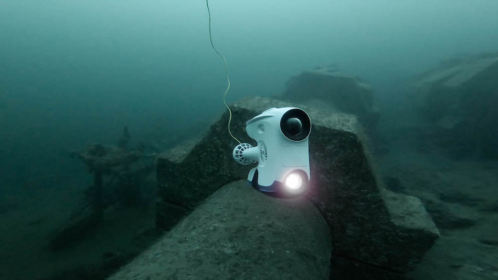
In January 2020, Norwegian technology company Blueye Robotics launched the Blueye Pro underwater drone, following on from its Blueye Pioneer underwater model originally launched in 2018.
With new features such as the camera tilt-function, improved camera quality and increased depth rating to 305m, Blueye users will have more flexibility to fulfil more use cases for underwater inspections.
“With the Blueye Pro we can offer professionals an even more robust and agile tool. With the new features such as the tilting camera and the increased depth rating, I’m confident that the Pro will serve the needs of professionals within aquaculture, search & rescue, hydropower, public waterworks, research, shipping, harbours and more,” explains Christian Gabrielsen, CEO, Blueye Robotics
The company says the underwater drone is ready to be deployed in a few minutes with minimal training. Operating the drone is easy with the Blueye app on the already familiar iOS or Android device together with a user-friendly controller.
With the additional Dive Buddy app, users can include other managers to join the operation on multiple devices.
The camera tilt-function will allow users to increase their vertical field of view. By a simple tap on the controller, the camera on the drone will tilt upwards or downwards, enabling users to perform more efficient and higher quality inspections.
Combined with the possibility to manoeuvre the ROV both lateral and vertical, the Blueye Pro is a major upgrade that lets users move and see more freely during inspections.
In addition to the tilt-function, the camera is improved with higher light sensitivity, better dynamic range and image stabilization. It’s now possible to better utilise the light breaking the surface, and to capture a more detailed picture of assets below the surface, as the majority of professional inspections occur in challenging conditions.
Drones win honours
New drone systems from Doosan Mobility Innovation (DMI) have recently won honours in two of the categories in the CES 2020 Innovation Awards announced during the CES 2020 Exhibition, the world’s largest electronics trade show, held in Las Vegas in Nevada, USA from 7-10 January 2020.
Doosan’s hydrogen fuel cell drones are composed of a power pack, a miniaturized, lightweight fuel cell system that maximizes mobility by utilizing PEMFC (Proton-exchange membrane fuel cells) technology, and drone frames that use the powerpack as their main power source. The specific model name of the powerpack shown at CES is DP30 and the drone frame is DS30.
Doosan’s Long Endurance Fuel Cell Drone (DS30 with DP30) won a Best of Innovation Award in the Drones & Unmanned Systems Category. The DP30 Mobile Fuel Cell Powerpack also won an Honoree Award in the Sustainability, Eco-Design & Smart Energy Category.
The company’s hydrogen fuel cell drone significantly expands the use of drones by extending the flight time beyond that of battery-type drones, which can fly for only 20 to 30 minutes, to more than two hours.

With the capability of flying up to two hours on one charge, these long-endurance fuel-cell-powered drones can cover even large sites in a single flight, versus using multiple batteries and flight locations. Using the drones can also improve the safety of workers and prevent accidents by using aerial scanning rather than manual materials climbing.
Underwater operations and the use of ROVs
When it comes to underwater inspections, hydropower and dam owners often have the choice to use divers or remotely operated vehicles (ROV). In an interesting piece on its website, equipment manufacturer Deep Trekker says that combining the strengths of both divers and underwater ROVs creates a mutually beneficial relationship.
With divers facing a broad and potentially dangerous breadth of tasks, underwater drones can assist them to maximize efficiency, effectiveness and most importantly — safety.
First tested in the 1960s by the US Navy, underwater ROVs have evolved into sophisticated, versatile vehicles. The benefits of modern ROVs include quick deployment, minimal maintenance, extended dive times, increased safety, high-quality video and photo recording, easy to use, cost-effective and access to confined areas.
Deep Trekker has two underwater ROV models; the DTG3 and the Revolution.
The DTG3 is an intelligent and advanced vehicle. The mini observation-class vehicle is portable and easy to use, allowing operators to quickly deploy and inspect underwater environments.
Mission-ready with serious payload capabilities and advanced stabilisation, the Revolution is a completely re-imagined ROV. The patented-pending revolving head allows operators to rotate the camera, manipulators and sonar all while station holding in moving water.
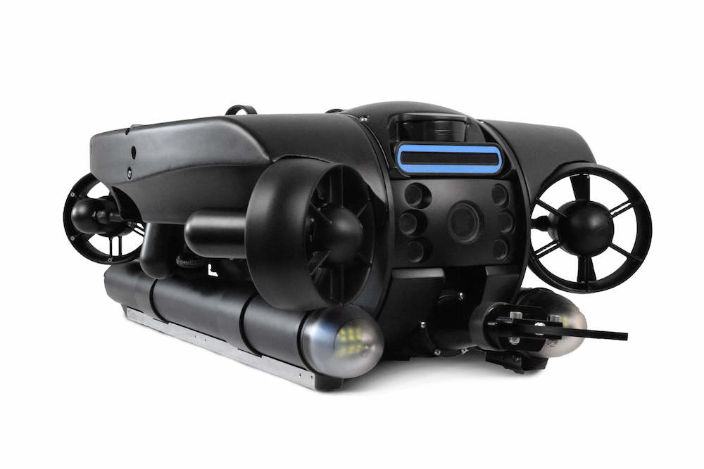
ROVs and pre-dive inspections
Using an ROV to conduct pre-dive inspections can increase safety and efficiency, ultimately saving time and money.
The ROV can survey dive areas before sending down a human being, checking for any potential safety risks and determining the lay of the land. With an ROV, pre-dive checks are safe and quick — providing dive teams with a reliable way to confirm the safety of their mission.
Furthermore, a pre-dive check with an ROV allows operators to determine tasks before deploying a diver. Before a diver even dips a toe in the water, the ROV can be deployed to identify the area that needs to be worked on.
Deploying an ROV before a dive allows stakeholders to see exactly what needs to be done and where, ensuring that all of the appropriate equipment is assembled and prepared before diving in. In doing this, divers can be fully equipped to fix underwater issues and business owners can accurately quote clients.
By conducting a pre-dive check, personnel have the opportunity to brainstorm solutions together. The diver does not have to independently assess the situation and come up with a solution all while operating on a limited supply of oxygen.
With the pre-dive ROV check, teams can come up with the best possible solution while optimizing time and money.
Diver safety can also be optimized with the use of an ROV. By monitoring divers from topside, operators can ensure safety and security for divers.
By piloting an ROV to monitor divers, those topside can ensure that divers are safe and following safety protocols. Real-time video observation allows any issues to be caught immediately with immediate emergency assistance if necessary. Whether open water or confined spaces, real-time monitoring is incredibly beneficial for scuba-diving safety.
Recording dives accurately
Operating an underwater robot from topside also allows for the dive to be accurately recorded. Recording dives provides numerous benefits for dive teams and companies.
Commercial diving companies can show the video to their clients to demonstrate their valuable and important work. Companies can also review dive footage to learn where improvements could be made to optimize operations.
Finally, recorded videos can be used for training purposes at both dive centres and commercial diving companies to demonstrate specific diving procedures for students.
Deep Trekker ROVs have the add-on option of diveable control systems. Completely submersible and depth rated to 75m, the handheld controller allows divers to take the entire Deep Trekker ROV system beneath the surface with them.
The diveable control system provides divers with a useful tool to maximise their time underwater. Add ons like grabber arms, sediment samplers, and thickness gauges allow the ROV to perform underwater tasks. Using the diveable control system, divers can perform underwater tasks in tricky areas to avoid entering dangerous zones themselves.
Divers can send the ROV into a hazardous scenario or confined space before going in themselves. Divers can stay safe and completely avoid unnecessary risks by using the ROV in place of a human being. By using the ROV to check out a potentially dangerous space, divers can avoid tricky situations completely.
Furthermore, sending the ROV into difficult spaces lets divers confirm conditions if they must enter that area themselves.
Allowing divers to work closely with an ROV can improve effectiveness, efficiency and safety. In addition to providing divers with a valuable underwater tool, the diveable controller lets divers check out dangerous spaces without having to go in themselves.


