
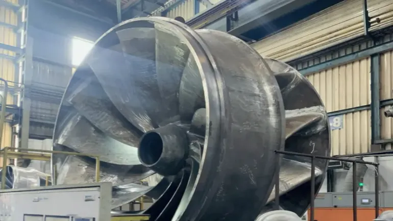
Toshiba Hydro Power (Hangzhou) (THPC), a joint venture between Toshiba and China’s Power Construction Corporation, has embraced advanced 3D scanning technology from Scantech to ensure the production of products for global customers.
Hydropower equipment is not without its share of challenges. These components are exposed to a myriad of environmental factors, including vibration, humidity, temperature fluctuations, and corrosion. To guarantee optimal performance, longevity, and efficiency, it becomes imperative to develop more advanced equipment capable of meeting the burgeoning industry’s demands for higher capacity and speed.
While traditional measurement methods still serve their purpose, they grapple with inefficiency, high personnel requirements, and time-consuming operations. Often, they fall short in providing comprehensive measurement data crucial for maintenance and repair.
In contrast, advanced 3D scanning technology offers diverse solutions to hydropower equipment manufacturers, from product design and production to maintenance. By utilizing Scantech’s TrackScan-Sharp, an optical 3D laser scanner, operators can perform Non-Destructive Testing (NDT) to ensure equipment quality. Improved quality translates into extended hydropower system service life, reduced losses, and enhanced overall efficiency.
Scantech’s optical 3D scanning system boasts several advantages, including free and wide-range measurements, high-precision measurements for various scenarios, advanced and efficient 3D scanning, and real-time inspection reports. The system’s industrial camera and expansive tracking volume facilitate high-resolution, wide-range measurements, eliminating the need to frequently relocate the tracker, which is ideal for measuring large hydropower equipment components.
These capabilities translate into high-precision measurements for various tracking ranges, allowing for the capture of fine details on medium and large hydropower equipment components. Furthermore, TrackScan-Sharp streamlines the scanning process by eliminating the need for targets, saving time on their application and removal, and even enabling the simultaneous scanning of multiple parts.
The 3D software integrated into TrackScan-Sharp captures, analyzes, and stores data in real time. This allows for the creation of colour maps and data archiving, ultimately facilitating precise assessments of part conditions to deliver high-quality products.
Scantech’s 3D scanning solutions are making a significant impact on the energy engineering field, enabling the digital transformation and upgrading of various large-scale energy enterprises, including the inspection of hydraulic turbine guide vanes, turbine castings, oil and gas pipelines, and wind power flanges.
Empowering Low-Carbon Planning in Malaysia
The Malaysian Ministry of Natural Resources, Environment and Climate Change, in collaboration with the Malaysian Green Technology and Climate Change Corporation, has taken a stride forward with the launch of the Malaysia Climate Action Simulator (MCAS). This groundbreaking tool empowers users to simulate low-carbon scenarios up to the year 2050. Funded by the UK Government’s International 2050 Calculator Programme and supported by technical partners, Mott MacDonald, Imperial College London, Ricardo, and CLIMACT, MCAS offers a dynamic visualisation of Malaysia’s carbon emission trajectory and facilitates a comprehensive exploration of diverse pathways to mitigate greenhouse gas (GHG) emissions across critical sectors, including energy, transport, building, industry, land use and waste.
MCAS is a versatile communication tool to increase public awareness about the critical role of technology, policy, and behaviour in reducing GHG emissions. It is also a valuable reference tool for businesses transitioning towards green technology solutions. Featuring an interactive and user-friendly web interface, MCAS empowers users to simulate different behaviours, navigate technological options, select potential pathways, and identify sector-specific roles.
It offers a common language for discussion on climate change mitigation measures, providing the means to plan and visualise decarbonisation pathways and make a comparative analysis. MGTC will actively engage potential users through events dedicated to introducing and demonstrating MCAS as an educational and awareness communication tool. This outreach will primarily target industry stakeholders, universities, research institutes, non-governmental organisations and the public.
“MGTC has strategic plans to collaborate with universities in developing educational modules centred around MCAS and integrating it into the university curriculum,” said Chief executive officer of MGTC, Ts. Shamsul Bahar Mohd Nor. “Additionally, MCAS remains open for further research contributions, aiming to facilitate more informed and rational decisions on various pathways to mitigate GHG emissions in Malaysia.”
Her Excellency Ailsa Terry CMG, British High Commissioner to Malaysia, said, “The UK is working closely with international partners like Malaysia to address the global climate challenges. Since 2012, the UK has committed £6M of International Climate Finance to the international community to support the creation of their respective 2050 Calculators. So far, we have helped create 19 national and six regional Calculators which have been used to develop NDCs and action plans, raise awareness and inform long-term strategies. The launch of MCAS is a culmination of our knowledge-sharing and technical collaboration with Malaysia, and I am pleased that it plays a role in mitigating greenhouse gas emissions across key sectors in Malaysia. This is part of our ongoing ambitious partnership with Malaysia to address the shared challenge of climate change and energy transition.”
Mott MacDonald’s 2050 Calculator programme country manager for Malaysia, Danny Giam, said: “Having overseen the delivery of the Malaysia Climate Action Simulator (MCAS) since the start of the programme, we’re excited to see it come to fruition. It will be an important enabler in Malaysia’s journey to achieve zero net emissions by 2050, and we look forward to seeing the tool further adopted by stakeholders in the near future.”
To access the Malaysia Climate Action Simulator (MCAS) webtool visit www.mcas.my.
Global Hydro Intelligence for Water Resource Security
Scientists with the U.S. Army Engineer Research and Development Center’s (ERDC) Coastal and Hydraulics Laboratory (CHL) are exploring potential opportunities by utilizing Global Hydro Intelligence (GHI) to answer questions about the nation’s bodies of water and the possibilities available for scientists to research.
GHI – a collaboration between ERDC, NASA, the US Air Force, the National Geospatial Agency, and Oak Ridge National Laboratory – is the integration of remote sensing, atmospheric, land surface, and hydrological models that provide on-demand hydrological data at the global scale to support Department of Defense (DOD) contingencies and resource protection and provide data to answer water security-related questions. Simply put, GHI could be the answer to mitigating catastrophic flooding globally.
“Imagine watching the national or global news – chances are there is a breaking story about a flood that devastated a community, city, or country,” Sarah Lytle, a research physical scientist at CHL, said. “Now imagine having a tool that could predict when, where, and how severe future flooding events happen within a reasonable amount of uncertainty all over the globe.”
Predicting the severity of storms is only one of GHI’s possibilities. Lytle said that GHI’s potential ranges far, giving scientists critical information to current and future challenges.
“The possibilities are vast. Water scarcity, extreme flooding and daily availability could be life-saving information. GHI represents a critical step to understanding the present and future ways we will be affected by Earth’s most precious resource,” Lytle said.
GHI aims to provide a comprehensive hydrological modelling framework that will serve as an authoritative source for the U.S. military, federal government, and intelligence community.
Matthew Geheran, a CHL research civil engineer, believes critical information learned from analyzing GHI provides scientists with solutions to combat domestic risks and potential global conflict over water resources.
“The US intelligence community has identified coordination of shared water resources as an important national security concern,” Geheran said. “The GHI framework will provide authoritative and timely information that will improve the ability of the United States to respond to water-related threats around the world.”
Dr. Ahmad Tavakoly, a research hydraulic engineer at CHL, believes in GHI’s ability to be a resource to several agencies and stakeholders.
“GHI provides an operationally trusted source of global hydro-intelligence information supporting OCONUS warfighters, planners, and decision-makers at all echelons and services of the U.S. military, the federal government, and intelligence community,” Tavakoly said.
As this planet’s climate shifts, Lytle and fellow scientists aim to utilize research and their data to improve GHI, creating a safer environment.
“It’s a living project, meaning as we better understand our climate, GHI is updated to improve with the latest scientific advancements for ERDC and its partners. It’s a true inter-agency effort, and in the three years I’ve worked with it, I’ve seen it continually improve and grow to become an unrivalled capability in hydrological forecasting,” Lytle said.
This article first appeared in International Water Power magazine.


